Week Four - Goodbye to the Sea
First of all, apologies for the late posting of this blog update, I always said that posts would be subject to internet access, but didn’t suspect that I would have more problems in northern Somerset than I had in deepest Cornwall. I’ve been using my phone’s 4G connection as a personal hotspot for the laptop to connect to the internet; this has always been a bit flaky, especially in the bottoms of valleys but for some reason the perfectly flat Somerset levels and rolling hills of the Mendips have by far the worst 4G signal so far.
An odd sort of week this week, after last week’s triumphal passing of the 200 mile mark and finishing the Cornwall, Devon and Somerset sections of the South West Coast Path week four has been much slower.
The Plan includes 1 day a week as a rest day, normally this is a Wednesday simply because I started walking on a Wednesday so it seemed logical to rest every seventh day. Last Wednesday was a particularly pleasant day off, Sandra was due to go South Shields for Sophie and Michael’s wedding on Thursday so we decided to enjoy the Wednesday together, first off was a trip to Ilfracombe, after stocking up the van with wine, beer and other necessaries, it was down to the fascinating Victorian Tunnels Bathing Experience.

Sandra at the entrance to the Victorian Tunnels Beaches

Can you spot Sandra, she’s out there somewhere!
In about 1836 a tunnel was cut though a cliff to a secluded bay and became a popular sea bathing experience for both men and, shock horror, women! It’s a fascinating place, and despite the tide being high and sea rough was quite safe to swim in, a fact that Sandra took full advantage of. After her “invigorating” swim it was off to Minehead which was to be our base for six nights.
Thursday was taken up with getting Sandra to Bridgwater in time for her to catch the train north for Sophie and Michael’s wedding then it was back to Minehead and some camp chores, clothes washing, van tidying etc. This took the rest of the day and turned Thursday into another rest day, that’s two days off in one week and I was definitely slacking.
Following the days off Arthur and I were itching to get going and at Minehead traded the South West Coast Path for the England Coast Path. For anyone interested in a truly long walk the England Coast Path is still being created but when it’s finished will follow the whole of the English coast, about 2600 miles, making it the longest coast path in the world. If you add in the Welsh and Scottish coast paths then it’s possible to walk the entire coast, about 4000 miles!
Arthur and I enjoyed a delightful stroll to a fishing village called Watchet which has a rather fine statue to “The Ancient Mariner”, it commemorates a particularly long poem by Samuel Taylor (smoke the opium, write the poem) Coleridge who lived nearby. There’s even a ‘Coleridge Way’ long distance path which we’d been following on and off when it coincided with the coast path; the official way-mark for the route is a small yellow feather which I presume refers to his literary activity. Part of me would love to see the route marked with a small opium pipe symbol, to honour the great poets contribution to romantic poetry and recreational pharmaceutical experimentation.

Apart from the statue Watchet also has a train station and bus stop. I’d have loved to have taken the train back to Minehead as it’s a fine heritage steam railway but this early in the season trains only run on Saturdays and Sundays, so we took the bus.
Our journey toward John O’Groats continued for the next few days, but without Sandra as support the pace northwards slowed down. We either got a bus or drive to a spot, walked for a few miles then retraced our steps to the van or bus stop. The is distances walked were fine but the ‘there and back’ process meant actual progress was halved.
Although it was a bit dispiriting to retrace our steps the days were prevented form being boring by the geology. So far I’ve mentioned the granite of Cornwall and the old red sandstone of Devon, the rocks East of Minehead changed again and the geology moved forward into the Jurassic. The cliffs were generally low shales and slates with easy gradients but the beaches were either shingle or vast expanses of bare blue-grey rock, a type of limestone called blue lias which is rich in marine fossils, particularly ammonites of various sizes.

Monday saw two highlights tick over, I turned my back on the sea and was reunited with Sandra. At Hinckley Point (largest engineering project in Europe with the biggest crane in the world) I bade farewell to the sea and headed inland toward Bridgwater, the Somerset Levels, the Mendips and Cheddar Cheese.
The sea has been a huge feature of the walk so far, for over 250 miles it’s been there on my left hand side, first the Atlantic and then the Bristol Channel, I’d grow used to seeing, hearing and smelling it; I’ve walked beaches and clifftops, watched the ebb and flow of the tide and was used to having the big sea views I could admire. At Hinkley point I turned sharp right and left it behind.
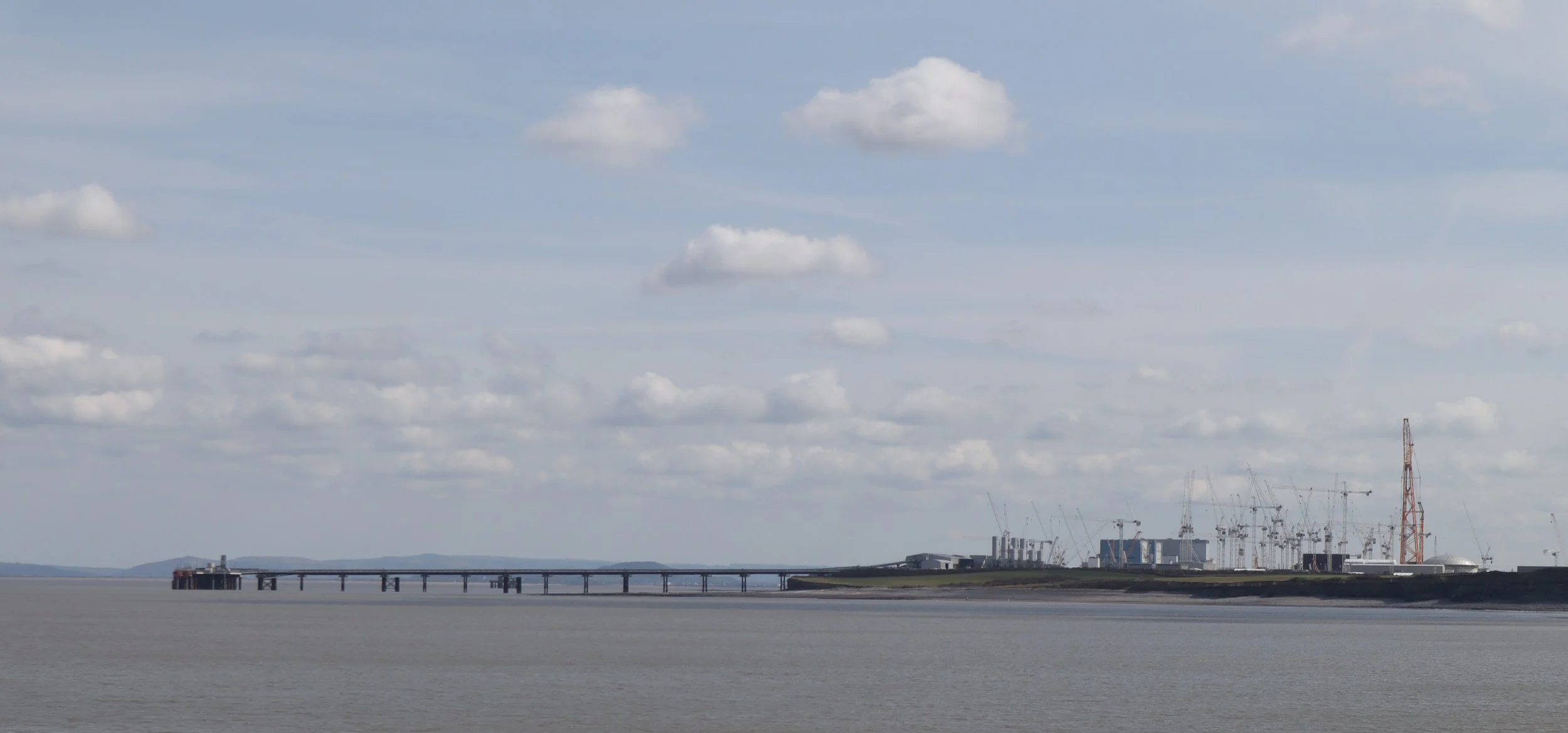
Hinkley Point, a huge project and the biggest crane in the world, Big Carl
It was probably psychological but it seemed that only a few meters from the coast the walking changed from wild sea scape to the pastoral delights of lanes and fields, with the Sommerset Levels stretching away to the distant blue line of the Mendips.
But before that I had to collect Sandra and reunited with the Support Team, we returned to Minehead and enjoyed a final opportunity to sit on the prom and eat fish and chips.

Heading inland from Hinkley brought me to Bridgwater, lowest crossing point on the Parrett River and the home of Carnival. Some people may have thought that Rio de Jannero or possibly Venice were the home of Carnival, but it is in fact Bridgwater in Somerset, and they have a statue to prove it.
Bridgwater’s other claim to fame is that it sits on the edge of the Somerset Levels. I’ve heard of them and read about them but never visited them; the Sommerset Levels are a vast area of ancient marsh much of which has been reclaimed for farming in the last couple of centuries. Before the work of reclamation was started the levels were famous as being more water than land, frequently flooded and invaded by the sea during the winter. Dotted across this watery landscape are ancient outcrops of higher land that stood above the marshes like islands; Glastonbury, aka the Isle of Avalon, is the most famous but there are several more.
Walking through the levels is surprisingly hard on the feet, the route either follows minor, traffic free roads or farm tracks and field paths. While the former and hard on the soles of the feet progress is fast and the miles tick by, however the later is surprisingly hard work; the paths are somewhat signposted, either with a generic yellow arrow or older green “Public Footpath” signs but they receive too little foot fall to be worn smooth, stiles are often missing or in poor repair and they frequently follow the tractor tracks along the field boundaries. The result is a very rough path that is surprisingly hard on both the feet and ankles.
I was half expecting the Levels to be boring walking, but this isn’t the case, while the land is undoubtedly flat (I’ve found over thirty square kilometres on the map without a contour line) its interests lie in its difference and the small and intimate. The fields are all surrounded by deep drainage ditches which are havens for plants and animals and the larger ones are often bordered by ancient pollarded willows.

Ancient pollarded willows beside a drainage ditch on the Somerset Levels.
There are also lots of birds in the hedges and waterways, the normal range of crows and small song birds are augmented by egrets, kestrels, ducks of several types, the occasional buzzard and heard more than seen, dozens of larks.
The week finished about halfway across the Somerset Levels, and for any one keeping track of the walk statistics, here’s this week’s update.
Total for week:- 57.5 Miles 4,150 Feet of Ascent, 127,722 Paces, 23.25 Hours of Walking.
Walk Total to date:- 274 Miles 34,780 Feet of Ascent, 621,482 Paces, 123 Hours of Walking.
Land’s End to John O’Groats walk 22% completed.